 Search
 EN/AR

Above Ground Biomass Evaluation and Monitoring System
27th July 2026
A Case Study for the Carbon Value Exchange (CaVEx) Platform (Kenya)
4 Earth Intelligence (4EI) delivered a remote sensing analysis conducted for 4RDigital’s Carbon Value Exchange (CaVEx) Platform. The project aims to reduce the costs associated with collecting data to validate carbon credits supporting reforestation initiatives. It achieves this by combining available ground data with remotely sensed imagery to validate tree planting and estimate carbon sequestration over time change detection efforts.
Project Objectives & Scope
The proposed Evaluation and Monitoring system was designed to address several core requirements:
- To validate tree planting and estimate the amount of carbon sequestered by trees using efficient, automated remote sensing techniques.
- To perform regular remote assessments to quantify the amount and quality of vegetation, monitoring these changes and growth through time.
- To detail the exact specifications, limitations, and costs of four distinct tiers of satellite-derived Above-Ground- Biomass (AGB) data products.
Methodology & Technical Approach
The project developed a multi-tiered approach to calculate AGB and carbon sequestration, adapting to different resolutions and data availabilities:
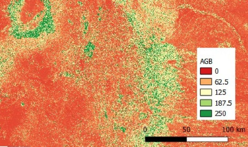
- Tier Four (100m Regional Instant Product): Utilises open-source datasets like Sentinel-1, Sentinel-2, ALOS SAR, and ESA CCI Biomass to train a regression model at a 100m resolution.
- This product provides an aggregated average AGB value scaled by a quantification factor to represent the sum of AGB over a regional area.
- Tier Three (30m Local Instant Product): Leverages L-band Synthetic Aperture Radar (SAR) imagery, which can penetrate cloud cover and tree canopies, making regular image acquisition simple.
- It builds a regression model to establish the relationship between HV backscatter and AGB at a 30m resolution, relying on calibration datasets such as the NCEO Kenya forest AGB map.
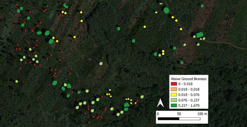
- Tier Two (0.3/0.5m Individual Tree Archive Instant Product): Uses archived Very High Resolution (VHR) commercial imagery, such as Pleiades Neo, to identify individual tree canopies through automated machine learning classification approaches.
- It derives canopy height using tree shadows combined with image metadata, and calculates trunk Diameter at Breast Height (DBH) from the canopy area using a fieldwork- enhanced regression model.
- AGB and sequestered carbon are then calculated for individual established trees utilizing specific allometric equations.
- Tier One (0.3/0.5m Individual Tree Future Product): Follows the exact same workflow as Tier Two, but involves the specific tasking of sensors to acquire newly collected, up- to-date data.
- System Architecture: The data ingestion and delivery system relies on a PostgreSQL database to manage the multi-tiered data.
- The FastAPI library is used to spawn a REST server that provides specific endpoints for each tier, sending warning messages if any parameters are missing during a client request.
Key Deliverables & Outcomes
The project successfully developed a scalable methodology for estimating above-ground biomass to support carbon credit validation for entities like farm cooperatives and large organisations.
- Open-source data (Tiers Three and Four) provides a cost-effective, kilometric understanding of environmental change that is highly accurate at a forest-wide resolution, though it is not suitable for individual tree analysis.
- VHR commercial imagery (Tiers One and Two) provides high-resolution data suitable for individual tree carbon stock calculations and visual auditing.
- Due to current costs and the resolution limits of identifying newly planted saplings, the approach is best applied at a regional level encompassing multiple smallholder farms rather than on a farm-by-farm localised basis.
- Future recommendations include integrating a tree health layer derived from NDVI for mature trees, and utilising deep learning models like U-Net to fully automate tree canopy inventories without the need for manual digitization.
Contact Information and Links
To find out more please get in touch or reach out to us at info@4earthintelligence.com.